The recent developments surrounding the seizure of a U.S. tanker have garnered significant media attention, especially following the latest satellite imagery updates. These images provide crucial insights into the incident, shedding light on the geopolitical implications and maritime security concerns in the region.
The U.S. tanker, which was reportedly seized by Iranian forces, has sparked a renewed debate over freedom of navigation in international waters, particularly in the strategically vital Strait of Hormuz. This waterway is crucial for the global oil supply, as a substantial percentage of the world’s oil shipments pass through it. The tanker incident not only poses immediate operational challenges for U.S. maritime interests but also raises alarm bells about Iran’s increasing assertiveness in the region.
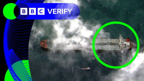
Satellite imagery has become an indispensable tool for monitoring maritime activities. It has enabled analysts to track the movements of the seized tanker, revealing its current location and any significant changes since the seizure. These images often showcase situations that are difficult to analyze through conventional means, particularly in remote or politically sensitive areas. They have frequently been used in conjunction with real-time intelligence to assess threats and strategize responses.
In this incident, updates from satellite technologies provided a clearer picture of the tanker’s condition, including potential damages or modifications made since the takeover. Analysts have been scrutinizing these images to understand the vessel’s orientation, any visible signs of crew activity, and whether it remains in the custody of Iranian forces or has been relocated. This level of scrutiny aims to gather actionable intelligence that could inform U.S. decision-makers as they contemplate potential military or diplomatic responses.
Moreover, the tanker seizure comes at a volatile time in U.S.-Iran relations, which have been strained since the U.S. withdrew from the Iran nuclear deal in 2018. Sanctions and counter-sanctions have led to an escalation of conflicts, not only on land but also at sea. Many experts are now questioning what this means for future engagements and whether maritime confrontations could become more common as both sides attempt to assert their influence.
As this situation unfolds, the interplay of satellite technology, naval power, and international diplomacy will be crucial in determining the next steps. The world will be watching closely how the U.S. and Iran navigate this tense scenario, as it may set precedents for future maritime disputes and shape the broader geopolitical landscape in the region. Ultimately, this incident serves as a stark reminder of the complexities of modern maritime security and the vital role that advanced technologies play in conflict resolution.
For more details and the full reference, visit the source link below: